
Ellijay GA Scenic Overlooks and Viewpoints: The Complete Guide for Visitors
- Thomas Garner

- Apr 17
- 13 min read
Updated: 6 days ago

Ellijay doesn't announce its scenery the way the higher peaks of the southern Appalachians do. There's no single dramatic summit, no famous roadside overlook with a parking lot and an interpretive sign. What Ellijay offers instead is something quieter and, for a certain kind of visitor, more rewarding: a pastoral mountain landscape of orchard-covered hillsides, river valleys framed by forested ridges, and elevated perspectives that reveal a softer version of the Blue Ridge Mountains than the rugged terrain further north.
Sitting at approximately 1,400 feet in Gilmer County — the self-proclaimed "Apple Capital of Georgia" — Ellijay occupies a wide valley where the Cartecay and Ellijay Rivers converge to form the Coosawattee River. The Chattahoochee National Forest rises on three sides of the valley, with ridgelines climbing toward the Cohutta Wilderness to the north and Fort Mountain to the southeast. The elevation gain from the valley floor to the surrounding summits is gradual enough that the views tend toward wide, layered panoramas rather than the sheer vertical drama of higher-altitude destinations — and that character is precisely what makes them distinctive.
For visitors based in Ellijay — and for STR hosts trying to help their guests find the experiences that generate five-star reviews — this guide covers the major scenic viewpoints accessible from town, from state park summits to pastoral valley drives to wilderness ridge walks, with the practical access and timing information that turns a vague recommendation into an actual plan.
What Makes Ellijay's Viewshed Different from Other North Georgia Mountain Towns
Before mapping specific overlooks, it helps to understand what you're looking at from them — because Ellijay's visual character is genuinely different from Blue Ridge, Dahlonega, or the higher terrain along the North Carolina border, and understanding that difference is what makes the views resonate rather than disappoint.
Most mountain overlooks in the southern Appalachians present variations on the same visual theme: forested ridgelines stacking into the distance, an unbroken canopy, and the sense of wilderness extending to the horizon. Those views are magnificent, but they're also relatively uniform — one ridgeline panorama looks broadly similar to another once the specific topography is abstracted.
Ellijay's best views are distinct in composition. The valley's agricultural heritage — orchards, hay fields, small farms, fenced pastures — creates a patchwork of managed landscapes within the mountain terrain, giving the scenery depth and human scale. A view from an elevated point above the Cartecay River valley doesn't show unbroken forest to the horizon. It shows apple orchards in ordered rows on the hillsides, with forest rising above them and ridgelines beyond that, and possibly a barn or a farmhouse anchoring the middle ground. This layered composition — cultivated land transitioning to forest, then to a mountain skyline — is what photographers mean when they describe Ellijay's scenery as painterly, and it's what draws the loyal following of landscape photographers and fall visitors who return year after year.
The fall foliage experience at Ellijay reflects this character. While higher-elevation destinations produce foliage that turns in waves of color, Ellijay's foliage season includes the orchards — apple trees in their own autumn colors, harvest activity visible on the hillsides, farm stands open along the roads — layered against the broader forest color on the ridgelines above. It's a working landscape in its most visually compelling season, and that combination of agricultural activity and natural color creates a foliage experience that can't be replicated in a pure wilderness setting.
Fort Mountain State Park: The Premier Elevated Viewpoint
Fort Mountain State Park, located approximately 20 miles southeast of Ellijay on GA-52, is the most accessible high-elevation viewpoint in the Ellijay orbit and the single most-referenced scenic destination in guest reviews of Gilmer County STR properties. The park sits atop Fort Mountain at around 2,800 feet — a 1,400-foot elevation gain from the Ellijay valley floor — and provides panoramic views across the Cohutta Wilderness to the north and the Georgia Ridge and Valley province to the south and east.
The Observation Tower
The park's stone observation tower, built by the Civilian Conservation Corps in the 1930s, offers one of the clearest 360-degree views in north Georgia. On clear days, the ridgelines extend far into Tennessee to the north and toward the Piedmont transition zone to the south. The tower provides sufficient elevation above the surrounding tree canopy to offer genuinely unobstructed views — a significant advantage over trail-level viewpoints, where seasonal foliage can limit sightlines.
The Cohutta Wilderness is the dominant visual feature from the tower's northern exposure. The wilderness canopy extends in unbroken forest to the horizon, with the Conasauga River drainage visible as a dark valley threading through the ridgelines. Looking south and east, the terrain transitions from mountain to foothill to the flatter agricultural landscape of the Georgia Piedmont — a geographic transition visible in a single panoramic sweep that communicates the scale of the Appalachian escarpment in a way that few individual viewpoints can.
Gahuti Trail and Ridgeline Views
The Gahuti Trail, an approximately 8-mile loop that circumnavigates Fort Mountain's summit, offers multiple ridgeline viewpoints that complement the observation tower with different perspectives and lighting conditions. The trail passes through mature hardwood forest with periodic openings that frame views of the surrounding ridgelines — particularly compelling in fall when the canopy color is at peak and the morning light illuminates the eastern exposures.
For guests who want more than the drive-to-the-tower experience, the Gahuti Trail provides a half-day hiking option with genuine scenic payoff and moderate difficulty. The trail surface is well-maintained, the elevation changes are gradual, and the loop format means no backtracking — qualities that make it accessible to guests with moderate fitness levels while still delivering a substantive outdoor experience.
The Ancient Stone Wall
Fort Mountain's summit also features a mysterious stone wall of uncertain origin — a roughly 855-foot-long structure that has been attributed to various builders across centuries, from pre-Columbian indigenous peoples to early European settlers. The wall is a genuine curiosity and a conversation piece that adds historical and archaeological interest to the scenic visit. For guests who enjoy layering cultural and historical discovery onto their outdoor experiences, the stone wall provides a reason to linger on the summit beyond the view itself.
Timing and Conditions
Fort Mountain's fall foliage typically peaks at the summit elevation from late October through early November, running one to two weeks later than higher-elevation destinations in the Blue Ridge corridor to the north. The best visibility conditions are cool, clear mornings — particularly after overnight rain has washed particulates from the atmosphere. Weekend traffic during peak October can create congestion on the park access road and limited parking at the tower trailhead; early arrivals before 9 a.m. avoid the worst of the congestion and provide the best lighting for photography.
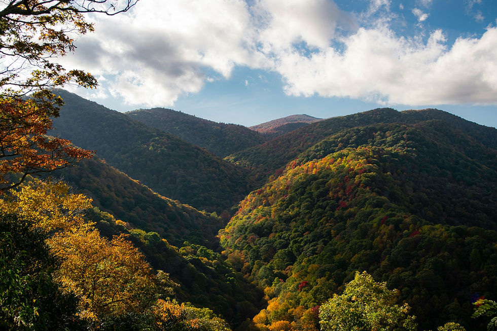
The Cartecay River Valley: Pastoral Mountain Photography at Its Best
The Cartecay River runs through a valley east of Ellijay that becomes one of the most photographed agricultural landscapes in north Georgia during fall. This isn't a single overlook — it's a corridor of elevated viewpoints along GA-52 heading east from town where the road climbs above the valley floor and the landscape opens into the kind of wide, layered composition that landscape photographers travel specifically to capture.
What You See
From the elevated pulloffs along GA-52, the Cartecay River valley presents a scene that is distinctly Ellijay: apple orchards in ordered rows climbing the hillsides, hay fields and pastures on the valley floor, the Cartecay River visible as a wooded corridor threading through the agricultural patchwork, forested ridgelines rising above the cultivated land, and — in October — the entire composition saturated with fall color at multiple scales. The orchards' autumn foliage, the deciduous forest on the ridgelines, and the golden tone of the harvested fields create a color palette that is warmer and more varied than the predominantly forest-green-to-red transition of higher-elevation destinations.
Why Photographers Value This View
Landscape photographers distinguish between panoramic views — wide, dramatic, and primarily about scale — and intimate views — smaller, more compositionally complex, and primarily about the relationship between elements within the frame. The Cartecay River valley provides the latter. The orchard rows create leading lines. The barn roofs anchor the composition. The river corridor provides depth. The ridgelines provide background. And the fall color provides the palette that ties the elements together. This compositional richness is why the Cartecay valley views generate social media and photography content at a rate disproportionate to their elevation or geographic fame.
Access and Timing
The GA-52 viewpoints are roadside — no hiking required. Several informal pulloffs along the eastbound route provide safe stopping points where the valley view opens up. The best photography conditions occur in the first two hours after sunrise, when the morning light illuminates the east-facing hillsides and the valley fog — common in October mornings — adds atmospheric depth to the scene. Late afternoon light, when the sun angle is low and the shadows are long, creates a different but equally compelling visual character.
Bear Creek Road and the Whitepath Scenic Drive
For guests who prefer scenic driving to hiking, the Bear Creek Road corridor and the surrounding network of rural routes in the Whitepath community northwest of Ellijay provide a slower-paced way to experience Gilmer County's hillside views. This is not a marked scenic byway with interpretive signs — it's a working rural road network that happens to pass through some of the most visually appealing agricultural mountain terrain in north Georgia.
Want to know what's holding your listing back? Get a free STR visibility audit.
The Route Character
Bear Creek Road and its connecting routes pass through orchards and small farms with mountain backdrops visible from nearly every stretch of the drive. The road rises and falls over low ridges, providing intermittent elevated views across the apple country landscape before descending back into the orchard corridors. During October, when the apple stands along the route are open and the trees are turning, the drive has a quality of immersion in the harvest season that can't be replicated from a single overlook — you're moving through the landscape rather than looking down on it.
The route is particularly rewarding on weekday mornings when traffic is minimal and the light is optimal. Weekend traffic during peak apple festival season can be heavy on the primary routes; guests who explore the secondary roads — the unnamed connectors between Bear Creek Road and the GA-52 corridor — find quieter driving conditions and often better views, because the secondary roads climb higher and provide more frequent elevated perspectives.
For STR Hosts
The Bear Creek Road drive is one of the best recommendations available for guests who aren't hikers but want a meaningful scenic experience. The entire route can be driven in 1 to 1.5 hours with stops, requires no special vehicle or physical fitness, and offers pastoral mountain scenery that defines Ellijay's visual identity. For families with young children, older guests, or anyone who simply prefers a relaxed morning drive with coffee to a summit hike, this is the recommendation that generates "we loved it" reviews.
Cohutta Wilderness: Ridge Views for Experienced Hikers
The Cohutta Wilderness, the largest federally designated wilderness area in the eastern United States, lies north of Ellijay in the Chattahoochee National Forest. Its ridgeline terrain — accessible from multiple trailheads off US-76 and forest service roads north of town — provides wilderness-scale views that are categorically different from the pastoral valley scenery closer to Ellijay.
What the Cohutta Views Offer
The views from the Cohutta ridgeline trails look across an unbroken forest canopy that extends to the horizon in every direction. There are no roads, no buildings, no agricultural clearings — just the dense hardwood and hemlock forest that has regenerated across the wilderness since its designation. The Conasauga River, one of the most biologically significant streams in the Southeast, threads through the wilderness interior in a valley visible from elevated ridge positions but inaccessible by road.
This is wilderness scenery in the truest sense — not a curated overlook with a railing and a plaque, but a ridge position reached by trail where the landscape below looks the way it has looked for centuries. For guests who seek that quality of experience, the Cohutta ridgeline views are among the most compelling available anywhere in the Southeast.
Access and Difficulty
Cohutta's viewpoints require genuine hiking on maintained but primitive trails. The Benton MacKaye Trail and connecting routes along the wilderness boundary ridge provide the primary access to viewpoint positions. Round-trip hiking distances to ridgeline views range from 5 to 12 miles, depending on the trailhead and destination, with substantial elevation gains on the steeper approach routes. These are not casual walks — proper footwear, water, and basic backcountry preparedness are necessary.
For STR hosts, Cohutta hiking recommendations should be calibrated to the guest's outdoor experience level. The wilderness rewards experienced hikers and can overwhelm casual visitors who underestimate the commitment required. Honest difficulty descriptions — "this is a serious half-day hike on a primitive trail, not a paved walkway" — prevent poor experiences while properly framing the reward for guests who are prepared.
Amicalola Falls State Park: A Day Trip Worth the Drive
Amicalola Falls State Park, approximately 30 miles southeast of Ellijay, contains the tallest cascading waterfall in the Southeast at 729 feet. The park is also the starting point for the approach trail to Springer Mountain, the southern terminus of the Appalachian Trail — a connection that gives Amicalola outsized cultural significance in the hiking community.
The Viewpoints
The Amicalola Falls experience provides multiple viewpoints. The falls themselves are visible from a series of staircase platforms that climb alongside the cascade — over 600 stairs from base to top — providing progressively expanding views of both the waterfall and the surrounding Blue Ridge foothills. The Amicalola Falls Lodge, perched above the falls, offers a broader eastward panorama toward Springer Mountain and the rolling Appalachian terrain that transitions from mountain to foothill over 30 miles of visible landscape.
The approach trail to Springer Mountain, which begins at the lodge and extends 8.5 miles to the AT's southern terminus, provides ridgeline views along its route that reward hikers who venture beyond the falls themselves. Most Ellijay-based guests will not hike the full approach trail, but even the first mile or two from the lodge provides elevated forest views that justify the additional effort.
Timing
Amicalola Falls is popular — significantly more visited than the Cohutta Wilderness or the rural scenic drives closer to Ellijay —, and the waterfall staircase can be crowded during peak hours on weekends. Early morning visits, arriving at the park by 8:30 a.m., offer the quietest conditions and the best lighting for photography. The falls face generally east, which means morning light illuminates the cascade directly while afternoon light backlights it — both conditions produce good photography, but the morning frontlight is more conventionally dramatic.
Spring visits during the azalea bloom (late April through early May) and fall visits during peak foliage (late October) are the most visually compelling seasons. Summer offers the fullest water flow after seasonal rain, and winter provides the most dramatic contrast between the bare hardwood canopy and the white cascade.
Seasonal Timing: When to See What
Ellijay's overlooks and viewpoints offer distinct visual experiences throughout the seasons, and the optimal timing depends on what the guest wants to experience.
Fall (mid-October through early November) is the peak viewing season and the highest-demand period for the area. The Apple Festival weekends in October draw heavy traffic — guests seeking scenic overlooks should plan early-morning departures and expect congestion on GA-52 and the primary routes. The reward is the area's signature visual combination: apple harvest activity on the hillsides, forest foliage on the ridgelines, and the golden pastoral light that defines Ellijay's autumn character. Fort Mountain's observation tower, the Cartecay valley pulloffs, and the Bear Creek Road drive are all at their visual peak during this window.
Spring (late April through May) offers azalea and wildflower bloom in the forest understory, dogwood flowering on the lower ridgelines, and the bright green of new canopy growth across the valley. Spring conditions are quieter than fall — fewer visitors, less traffic, more solitude at every viewpoint — and the light quality on clear spring mornings is excellent for photography. Amicalola Falls is particularly rewarding in spring, when water flow is strong, and the surrounding forest is in its freshest green.
Summer (June through August) provides the fullest canopy — the forest is at maximum density, the orchards are in full leaf, and the overall landscape is its deepest green. Summer afternoon thunderstorms produce dramatic sky conditions that create compelling photography opportunities for guests willing to be outdoors during unsettled weather. The light immediately after a summer storm — warm, low-angle, with residual cloud drama — is some of the best photography light available in the Georgia mountains.
Winter (December through February) strips the deciduous canopy, revealing terrain contours and long-distance views that are invisible during leafed-out months. The Cartecay valley in winter, with bare orchard rows and dormant fields against a grey sky, has a stark beauty that appeals to guests who appreciate landscape photography beyond the conventional foliage peak. Fort Mountain in winter, when the observation tower's views extend farther through bare canopy, offers some of the year's best long-distance visibility.
For STR Hosts: Building Viewpoint Knowledge Into the Guest Experience
The scenic viewpoints described in this guide represent the specific, locally informed content that separates an excellent STR hosting experience from a generic one. A guest who arrives in Ellijay, follows a host's recommendation to drive Bear Creek Road on a weekday morning, stops at the Cartecay valley pulloffs at sunrise, and visits Fort Mountain's observation tower after the fog lifts is going to have a fundamentally different trip — and write a fundamentally different review — than a guest who spent three days at the cabin without knowing what was available beyond the apple stands.
Ellijay's scenery isn't as vertically dramatic as the higher peaks to the north, and it doesn't need to be. What it offers is a pastoral mountain landscape with genuine visual depth, agricultural character that gives the scenery human scale and seasonal rhythm, and a quality of light and composition that rewards guests who know where to look. The hosts who help their guests find those views are building the kind of guest experience that generates loyalty, repeat bookings, and the enthusiastic word of mouth that no marketing budget can buy.
Crest & Cove Creative works with short-term rental operators and investors across North Georgia and Western North Carolina, including Gilmer County and the Ellijay market. Reach out to discuss listing optimization, guest experience strategy, and market positioning.
Start with a free visibility audit at crestcove.co/audit.
Work with Crest & Cove Creative
Ready to put this strategy to work in North Georgia?
Crest & Cove Creative partners with a select group of independent hosts in the Southeast each quarter — focused on listing quality, organic search visibility, and direct booking growth. If your property isn't reaching the guests it should be, that's exactly the kind of problem we solve. Reach out directly at crestcove.co — we'll take an honest look at where your listing stands and tell you plainly whether we can help.
Frequently Asked Questions
About the Authors
Crest & Cove Creative is a Southeast-focused short-term rental marketing agency founded by Thomas Garner and Jacob Mishalanie. We build direct-booking brands, listing optimization systems, and market-specific content strategies for independent STR operators across the Gulf Coast, Appalachian Mountains, Coastal Georgia, and Southeast lake country.
Related Reading
Explore more North Georgia short-term rental insights and guest guides:
The Dahlonega, GA Guide to Scenic Overlooks and Viewpoints You Won't Find on TripAdvisor
Planning a Trip to Blue Ridge GA? Here Are the Scenic Overlooks and Viewpoints That Make It Worth It
Blue Ridge GA STR Market Report: Downtown Walkability, Lake Blue Ridge, and High-End Cabin ADRs
Dahlonega & North Georgia Wine Country STR Market Report: Wineries, Weddings, and Weekender Stays
Urban vs. Cabin STR Markets in the Southern Appalachians: Yield, Risk, and Regulatory Trade-Offs
North Georgia Mountain STR Market Report: 2026 Trends and 2027 Outlook
Seasonal Photo Updates: Why Changing Your Listing Photos Four Times a Year Boosts Bookings
Bryson City vs. Blue Ridge, Georgia: An Honest STR Investment ROI Comparison for 2026
Your Ultimate Guide to the WNC Tourism Calendar: Maximizing Bookings Year-Round


Comments