
Planning a Trip to Blue Ridge GA? Here Are the Scenic Overlooks and Viewpoints That Make It Worth It
- Thomas Garner

- 5 days ago
- 11 min read
Updated: 2 days ago
Blue Ridge, Georgia, has become one of the most popular mountain destinations in the southeastern United States, and the reason is partly geographic: at approximately 1,700 feet in Fannin County, roughly 90 miles north of Atlanta via GA-400 and US-76, it sits at the intersection of accessibility and genuine mountain character in a way that very few towns in the region can match. An Atlanta professional can leave the office on a Friday afternoon and be sitting on a cabin porch above Lake Blue Ridge before sunset. That proximity has made Blue Ridge one of the highest-demand STR markets in north Georgia — but for guests who arrive and want to know where to go for the views that justify the trip, the answer isn't always obvious from the cabin.
Blue Ridge's viewshed doesn't announce itself the way a Blue Ridge Parkway corridor town might. The town sits in a valley, and the best views require effort — a drive up a mountain road, a hike along a wilderness ridgeline, an early morning visit to a dam overlook when the fog sits in the river valley below. The guests who find those viewpoints say they are the highlight of their trip. The guests who don't may come away thinking Blue Ridge is all about the railroad and the downtown shops. Both experiences are valid, but only one captures the landscape that makes this part of the southern Appalachians extraordinary.
This guide covers the major scenic overlooks and viewpoints accessible from a Blue Ridge base, organized by character and distance, with the practical access information that turns a general recommendation into an actual plan.
Blue Ridge's Landscape Context: Mountains, Water, and Wilderness
Before mapping specific viewpoints, it helps to understand what you're looking at from them, because the landscape surrounding Blue Ridge is more varied and more geographically significant than many visitors realize.
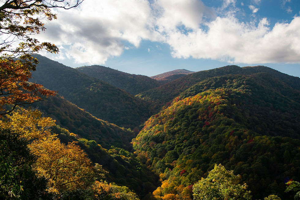
Blue Ridge sits in the Toccoa River valley, a drainage that flows north into Tennessee before joining the Ocoee River system. The town is bordered to the south and east by the Chattahoochee National Forest, which encompasses over 750,000 acres of public land across north Georgia. Within that forest boundary lies the Cohutta Wilderness — the largest federally designated wilderness area in the eastern United States — and the Rich Mountain Wilderness, both of which contribute to the sense of unbroken forest that defines the view from Blue Ridge's surrounding ridgelines.
To the southeast, the terrain rises toward Brasstown Bald, the highest point in Georgia at 4,784 feet — a 3,000-foot elevation gain from the Blue Ridge town center to the summit, achieved over roughly 30 miles of mountain road. To the west, Lake Blue Ridge fills the impounded Toccoa River corridor with nearly 3,300 acres of water surface surrounded by National Forest land. To the north, the Tennessee border and the Ocoee River gorge create a landscape transition from the rounded southern Appalachian ridges to the sharper terrain of the Tennessee Valley Divide.
This is the viewshed that Blue Ridge overlooks. It's a landscape of stacked ridgelines, wilderness canopy, lake corridors, and dramatic elevation changes by eastern US standards — and the viewpoints that reveal it are among the best reasons to visit this part of the southern mountains.
Brasstown Bald: The Summit Experience That Defines North Georgia
Brasstown Bald is the single most significant viewpoint accessible from the Blue Ridge, and it deserves that designation without qualification. At 4,784 feet, it is the highest point in Georgia, and its maintained summit observation deck provides a 360-degree panorama that encompasses portions of four states on clear days: Georgia, North Carolina, Tennessee, and South Carolina.
The drive from Blue Ridge to Brasstown Bald takes approximately 45 to 60 minutes via US-76 east toward Blairsville and then GA-180 south to the Brasstown Bald access road. The access road climbs steeply from GA-180 to a large parking area below the summit. From the parking area, a paved but steep half-mile trail leads to the summit observation deck and visitor center. For guests who prefer not to hike the summit trail, a shuttle service operates seasonally from the parking area to the top.
What You See from the Summit
The summit panorama is genuinely extraordinary. Looking north, the ridgelines of the Nantahala National Forest in North Carolina are visible, with the higher peaks of the Black Mountains and the Great Smokies on the distant horizon. Looking east, the terrain descends toward the Piedmont in a series of progressively lower ridges. Looking south, the Georgia mountains give way to the rolling foothills that eventually flatten toward Atlanta. Looking west, the Tennessee Valley Divide and the ridgelines above the Ocoee River corridor are visible as a continuous forest line.
The scale of the view is what distinguishes Brasstown Bald from other regional viewpoints. Most high-elevation views in the southern Appalachians are partially obstructed by surrounding peaks or by the forest canopy on the summit. Brasstown Bald's maintained meadow summit and constructed observation deck provide the kind of unobstructed, full-horizon visibility that is genuinely rare in the eastern mountains. Guests who have never experienced a true 360-degree summit view consistently describe it as perspective-altering — a visual understanding of the southern Appalachian landscape's scale that cannot be communicated through photographs or descriptions.
Timing and Conditions
Visibility is the critical factor for a visit to Brasstown Bald. The summit is frequently in cloud during the afternoon hours in summer, and haze can significantly reduce long-distance visibility during warm months. The best conditions for maximum visibility are cool, clear mornings — particularly after overnight rain, when the atmosphere has been washed clean, and the post-storm light produces dramatic color and contrast. Fall mornings in October, when the foliage color is developing on the surrounding ridgelines and the air is typically clearest, consistently produce the best Brasstown Bald experiences.
The access road is seasonal — typically open from late spring through late fall, with specific opening and closing dates varying by year. Guests planning a visit outside the summer peak should confirm road status with the Brasstown Bald Visitor Center or the Blue Ridge Ranger District before driving.
Cohutta Wilderness Overlooks: Earned Views in the Largest Eastern Wilderness
The Cohutta Wilderness, located in the Chattahoochee National Forest south of Blue Ridge, is a 36,977-acre roadless area — the largest federally designated wilderness in the eastern United States. The wilderness protects the headwaters of the Jacks and Conasauga rivers in terrain that has been inaccessible to logging and development for decades, producing an unbroken forest canopy visible from ridge positions that feels genuinely remote despite being 90 miles from metropolitan Atlanta.
What Makes Cohutta Views Different
Cohutta's viewpoints are fundamentally different in character from the summit panorama at Brasstown Bald or the water-and-mountain views at Lake Blue Ridge. These are wilderness views — the landscape visible from the ridgelines above the Cohutta looks exactly as it did before European settlement, because the wilderness designation has preserved it in a functionally unaltered state. There are no roads visible, no buildings, no cleared agricultural land. The canopy extends unbroken to the horizon in every direction, and the only sounds from the ridgeline are wind and wildlife.
This character is the draw. Guests who specifically seek natural solitude and a sense of genuine wildness — not curated, not manicured, not accessible by car — find the Cohutta views among the most memorable outdoor experiences available anywhere in the Southeast.
Access Routes and Trail Options
Cohutta's viewpoints are reached by trail, not by road. The two primary trail systems that access ridge views above the wilderness are the Benton MacKaye Trail, which traverses the wilderness boundary ridge, and the Pinhoti Trail system, which connects to the Cohutta from the south.
The most accessible Cohutta ridgeline views from a Blue Ridge base are reached via the Jacks River Falls trail corridor and the Hemp Top trail system, accessed from forest roads south of Blue Ridge. These hikes range from moderate to strenuous, with round-trip distances of 5 to 12 miles depending on the specific ridge destination. They are not casual walks — proper hiking footwear, water, and basic navigation awareness are necessary. But the payoff for hikers who reach the ridgeline is a wilderness view that cannot be replicated from any roadside overlook in the region.
For STR hosts building guest guidebooks, Cohutta recommendations should be calibrated to the guest's fitness level and outdoor experience. The wilderness rewards experienced hikers but can overwhelm casual visitors who underestimate the distance and terrain. Honest guidance about the difficulty — paired with an enthusiastic description of the reward — prevents bad experiences while encouraging guests who will genuinely appreciate what the Cohutta offers.
Lake Blue Ridge Dam Area: The Accessible Morning Viewpoint
Lake Blue Ridge, impounded by the Blue Ridge Dam on the Toccoa River in the 1930s, covers nearly 3,300 acres of water surface surrounded by Chattahoochee National Forest land. The dam area, accessible off Old Highway 76 just west of the Blue Ridge town center, provides elevated views of the lake, the Toccoa River valley below the dam, and the surrounding forested ridgelines — all without any hiking requirement.
The Morning Fog Phenomenon
The Lake Blue Ridge dam overlook is at its most visually compelling in the early morning hours, when temperature inversions trap fog in the Toccoa River valley below the dam while the ridgelines above remain clear. The result is a classic Appalachian mountain valley scene: fog sitting in the valley floor like liquid, the forest ridgelines emerging above it in sharp outline, and the lake surface catching the first morning light before the fog burns off. This atmospheric condition occurs most frequently in fall — September through November — when cool overnight temperatures and warm daytime conditions create the temperature differential that produces valley fog.
Want to know what's holding your listing back? Get a free STR visibility audit.
Guests who visit the dam overlook at 7:30 a.m. on an October morning are likely to see one of the most photogenic natural scenes in Fannin County. Guests who visit at noon will see a pleasant lake-and-mountain view. The difference is dramatic, and hosts who include this timing guidance in their guest communications create the conditions for an experience that generates enthusiastic reviews and social media sharing.
Lake Access Viewpoints Beyond the Dam
The lake's irregular shoreline and surrounding National Forest land create additional viewpoints accessible by car and a short walk. Morganton Point Recreation Area, on the lake's northern shore, offers views of the water framed by forested ridges. The boat ramp areas along the lake's eastern arm offer views back toward the dam and the higher ridges to the south. For guests who rent kayaks or paddleboards — available from several operators in the Blue Ridge area — the on-water perspective offers a view that no shore-based overlook can replicate, with the surrounding mountains reflected on the early-morning lake surface.
Dockery Lake and the Northern Cohutta Approach
Dockery Lake sits at approximately 2,400 feet in the Chattahoochee National Forest, about 15 miles south of Blue Ridge via US-19/129 toward Dahlonega. It is a small, quiet lake — significantly more intimate than Lake Blue Ridge — surrounded by hardwood forest with ridgeline views to the east that provide a contained, peaceful mountain-and-water scene.
The Lake Loop Trail
The one-mile trail around Dockery Lake is flat, well-maintained, and suitable for all ages and fitness levels — one of the few genuinely accessible viewpoint-adjacent trails in the Blue Ridge orbit. The trail passes through mature forest, with the lake visible through the trees, and several viewpoint clearings provide direct lake-and-ridge views that are particularly photogenic in fall, when the surrounding hardwoods turn. For families with young children or guests with limited mobility who want a forest-and-mountain experience without the physical demands of a wilderness hike, Dockery Lake is a strong recommendation.
Appalachian Trail Access from the Dockery Lake Corridor
The Appalachian Trail passes through north Georgia on its way from Springer Mountain to the North Carolina border, and trail access points near Dockery Lake — including the Grassy Ridge and Slaughter Creek trail junctions — provide ridgeline views accessible from moderate day hikes. The AT ridgeline in this section offers views across the Chattahoochee National Forest canopy and, on clear days, south toward the foothills transitioning toward the Georgia Piedmont. These views are less dramatic in scale than Brasstown Bald's summit panorama but more immersive — the hiker is in the landscape rather than above it, walking along a ridgeline rather than standing on an observation deck.
Rich Mountain Wilderness and the Aska Trails Area
The Rich Mountain Wilderness, located immediately south of Blue Ridge in the Chattahoochee National Forest, protects approximately 9,649 acres of rugged terrain. The Aska Trails area, a network of hiking and mountain biking trails in the same forest corridor, provides access to ridgeline viewpoints among the closest high-elevation views of the Blue Ridge town center.
The Stanley Gap trail, accessible from the Aska area, traverses a ridgeline with intermittent views across Lake Blue Ridge and the Toccoa River valley. The trail's elevation gain is moderate, and the viewpoints along the ridge provide a different perspective on the Blue Ridge landscape than the dam overlook or the lake-level access points — you're looking down across the lake from the ridgeline rather than across it from the shore, which changes the visual relationship between water and mountain in a way that many guests find more compelling.
For guests who want a half-day hiking experience with genuine ridge views but don't want to commit to the full-day drive and hike required by Brasstown Bald or Cohutta, the Aska Trails area offers the best viewpoint-to-effort ratio available close to town.
Seasonal Timing: When to Visit for the Best Views
The north Georgia mountains present distinct visual characters in different seasons, and the optimal time to view depends on what the guest wants to see.
Fall (October) is the peak viewing season for both foliage color and atmospheric clarity. Lower-elevation viewpoints around Lake Blue Ridge and Dockery Lake peak in mid-to-late October. Brasstown Bald's summit hardwoods peak in early October — sometimes as early as late September in years with early fall temperature drops. The two-to-three-week gap between summit and valley color means guests visiting in mid-October can see peak color at lower elevations while the summit has already turned. October coincides with apple season at the orchards around Ellijay and the Blue Ridge corridor, creating a double draw that makes fall the highest-demand period in the regional STR market.
Spring (April through May) offers quieter conditions and the wildflower season in the Cohutta Wilderness and Chattahoochee National Forest understory. The forest floor produces trillium, bloodroot, and dozens of other wildflower species before the canopy leafs out, creating an ephemeral visual display that rewards guests who prefer botanical beauty over panoramic scale. Spring trail conditions are typically wetter, and waterfall flow in the surrounding forest drainages is at its annual peak — making waterfall-adjacent hikes more rewarding than during drier months.
Summer (June through August) provides the longest days and the warmest lake temperatures, making it the optimal season for on-water viewpoint experiences — kayaking, paddleboarding, and boat-based lake views. Summer heat and humidity reduce visibility at high elevations, making Brasstown Bald visits more dependent on early-morning timing to beat afternoon haze and cloud development.
Winter (December through February) strips the deciduous canopy from the forest, revealing rock formations, terrain contours, and long-distance ridgeline views that are invisible during leafed-out months. Winter ridge views from the Aska area and the Cohutta boundary trails are dramatic, surprising guests who assume mountain views are a summer and fall experience. Lake-level fog and frost on clear winter mornings create some of the most atmospheric landscape photography conditions in north Georgia.
For STR Hosts: Viewpoint Knowledge as a Competitive Advantage
The scenic viewpoints described in this guide are not proprietary knowledge, but they might as well be — because the vast majority of Blue Ridge STR listings don't reference them specifically enough to help a guest find and experience them. A host whose welcome guidebook includes Brasstown Bald timing advice, Cohutta trail recommendations calibrated to guest fitness level, the early morning fog window at the Lake Blue Ridge dam overlook, and the Dockery Lake loop as a family-friendly alternative is providing the kind of specific, locally informed value that guests remember and review.
The guest who arrives in Blue Ridge, follows a host's viewpoint recommendations, catches the sunrise fog at the dam, drives to Brasstown Bald on a clear October morning, and discovers the Dockery Lake loop with their kids, is going to write a different review than the guest who spent three days on the cabin porch without knowing what was available to them. The first guest is an advocate for the property and the destination. The second guest had a fine trip. The difference between those two review types — over dozens of bookings — is a meaningful competitive advantage for the host who invested the time to build the knowledge and share it.
Blue Ridge's views are real. The hosts who help their guests find them will always outperform those who don't.
Start with a free visibility audit at crestcove.co/audit.


Comments