
Cloudland Waterfalls and Sitton's Gulch: A Different Trailhead Than

Updated: Aug 27
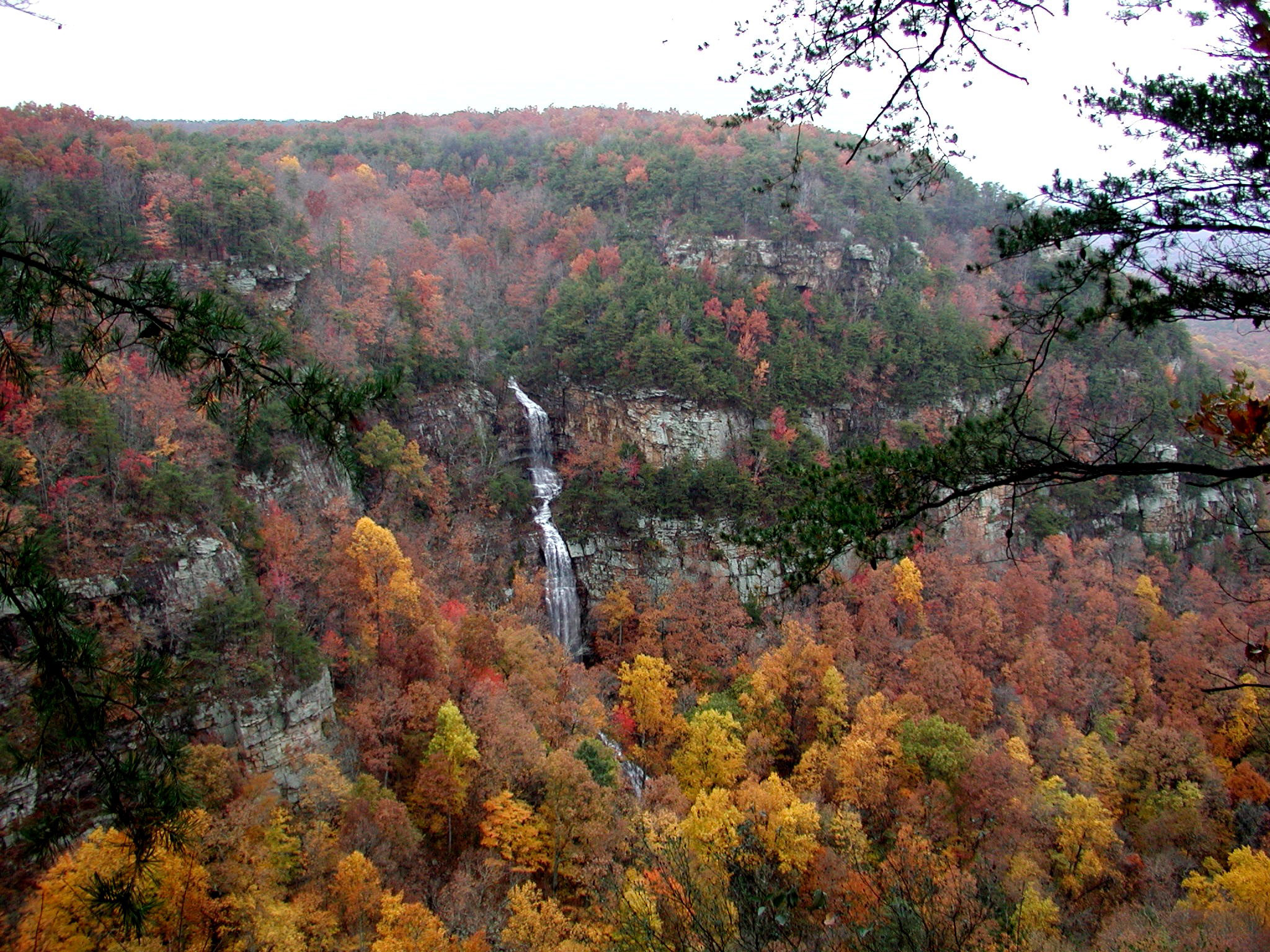
Cloudland Canyon State Park has two distinct hiking experiences, and hosts near Rising Fawn who market the park as one interchangeable attraction are underselling both. The West Rim Trail, covered in its own separate guide, is an overlook walk along the canyon's edge. The Waterfalls Trail and Sitton's Gulch, covered here, is a descent to the canyon floor -- six hundred metal stairs down, two named waterfalls, and a creek-side trail that runs out toward Trenton. These are not the same hike, and a guest sold one while expecting the other is going to have a mismatched day.
Confirm current trail conditions, hours, and the exact lower-lot name with the park directly before sending a guest -- park logistics change, and this guide states plainly where the research behind it could not confirm a detail rather than guessing at one.
Cloudland Canyon's Park Pass is $10 for a daily pass or $70 for an annual pass. That is the one dollar figure in this guide, and it applies to park entry generally, not to any specific trail. This is not legal advice.
Starting at the Main Trailhead, Then Deciding How Far Down to Go
The Waterfalls Trail starts at the park's main trailhead, the same general area most visitors first arrive at which makes it an easy trail to point a guest toward without complicated directions. What is not simple is the trail itself: this is a descent into the canyon, not a level walk, and a guest should decide before they start how far down they actually intend to go.
The trail offers a real decision point partway down -- a guest can turn back after reaching the first waterfall without ever seeing the second, or continue further for a longer, more strenuous round trip. Framing that choice explicitly in a listing's local-area notes gives a guest permission to turn back without feeling like they failed to complete the hike.
That framing matters most for guests who are not experienced hikers. A trail description that only says "waterfall hike, moderate" does not communicate that a six-hundred-stair descent is a meaningfully different commitment than a flat half-mile walk, and a host who treats those two things as interchangeable is setting an inaccurate expectation.
Six Hundred Metal Stairs and the Grate
The descent to the canyon floor runs roughly six hundred metal stairs, which is the single most important physical fact a host can give a guest before they start this hike. That is not a casual walk down a hillside -- it is a sustained metal staircase, and the return trip means climbing the same six hundred stairs back up, which is a genuinely different physical demand than the descent.
A metal grate section partway down the stairs is worth mentioning specifically for guests bringing dogs. A dog that is fine on a dirt trail may balk at or need to be carried across a metal grate, and a host who has not walked the trail themselves and confirmed this detail is guessing at whether their listing's "dog-friendly hiking nearby" claim actually holds up on this specific trail.
If a listing is marketing a dog-friendly canyon morning, the honestly dog-friendly version of that promise is the West Rim's Overlook Trail, not this descent. Six hundred metal stairs with a grate crossing is not the same commitment for a dog as a rim-level overlook walk, and conflating the two in a listing description sets a guest and their dog up for a bad morning.
Cherokee Falls at a Half Mile, Then Hemlock Falls Further On
Cherokee Falls sits at roughly the half-mile mark of the descent, making it a realistic turnaround point for a guest who wants the reward of a waterfall without committing to the full round trip. Hemlock Falls sits further along the trail, adding meaningfully more distance and descent for guests who continue past Cherokee.
Naming both falls specifically, rather than referring vaguely to "the waterfalls," gives a guest a plannable choice: a shorter out-and-back to Cherokee, or a longer trip that includes Hemlock. That distinction is the same kind of specificity that separates a listing written by someone who has actually hiked the trail from one written from a generic template.
These are the park's own stated distances, not a blog's estimate, and a host repeating them accurately is passing along information a guest can actually plan a morning around -- water bottles, footwear, and how much daylight to budget -- rather than a vague "there are waterfalls on this trail" mention.
Winter and Early Spring Are the Flow Months
Waterfall flow at Cherokee and Hemlock is strongest in winter and early spring, which is worth stating plainly to a guest booking a fall or late-summer stay who is picturing the falls at their most dramatic. A guest arriving in a drier month should be told honestly that the falls may be a trickle rather than the postcard version, rather than discovering that mismatch on the trail.
March in particular sits inside the park's higher-visitation window, which means a guest hiking during peak spring flow is also likely to be sharing the trail and the stairs with more people than a quieter month would bring. That is a real tradeoff worth naming: best water, busiest trail.
A host who sets this expectation accurately -- strong flow but more company in early spring, weaker flow but a quieter trail later in the year -- gives a guest the information to choose which tradeoff they'd rather have, instead of promising a peak-flow experience regardless of when they're actually staying.
Sitton's Gulch Follows Daniel Creek Toward Trenton
Past the waterfalls, the trail continues as Sitton's Gulch, following Daniel Creek out toward the town of Trenton, Georgia -- a genuinely different section of trail than the stairs-and-waterfalls portion closer to the main trailhead. This is the part of the hike that connects Cloudland Canyon to a second access point rather than looping back to where a guest started.
That connection is exactly why the lower, Trenton-side trailhead matters as its own topic: a guest who parks at the main trailhead and hikes all the way to the Trenton end has effectively done a one-way hike, and needs either a second vehicle or a plan to hike back the way they came. A listing that mentions Sitton's Gulch without mentioning this logistics detail is leaving out the fact that actually decides whether the hike works for a given guest's plans.
Both Rising Fawn, where the main trailhead sits, and Trenton, near the gulch's far end, belong in a host's local-area notes for this trail specifically -- not as two unrelated towns, but as the two ends of the same hike.
Confirming the Lower-Lot Name Before Sending Anyone
The Trenton-side trailhead lot goes by a specific name that the park itself sets and that this research pack could not confirm as stable across time -- park lot names and signage do change. Rather than printing a specific lot name here that might already be out of date, the honest instruction for a host is to confirm the current official name of that lower lot directly with the park before including it in a guest-facing message.
It's also worth confirming whether that lower lot sits inside the same Park Pass system as the main trailhead, since a guest planning to start or end their hike at the Trenton side needs to know whether a second pass purchase is required there.
This is the kind of detail that costs a host nothing to verify with one call or website check, and costs a guest a confusing, possibly wasted drive if a host guesses wrong. Confirm it at the week you actually send a guest, not from a note written months earlier that may no longer be accurate.
Rising Fawn and Trenton Both Belong in the Guest Book
Because this hike genuinely spans two access points, both Rising Fawn and Trenton deserve a mention in a host's guest-facing trail notes -- not as a courtesy nod to two towns, but because a guest driving to either end needs directions that actually start from the correct town. A note that only mentions Rising Fawn is incomplete for a guest planning to use or check out the Trenton-side access.
This also matters for a host describing their own listing's proximity to the trail. A Rising Fawn host is close to the main trailhead and the stairs-and-waterfalls portion of the hike; a listing near Trenton is closer to the gulch's far end. Those are two different claims about proximity, and a listing should make the one that's actually true for its specific location.
Naming both towns accurately, tied to the specific end of the trail each one is actually close to, is a small detail that signals real local knowledge to a guest doing their own research before booking.
Not Ruby Falls, Not DeSoto Falls, and One Pointer Back to the Rim
Cherokee and Hemlock Falls are genuinely different destinations than Ruby Falls or DeSoto Falls -- different parks, different access, different experience -- and a listing that lets a guest confuse them is setting up a wasted trip to the wrong location entirely. Naming Cloudland Canyon's falls specifically, rather than a generic "waterfalls near Chattanooga" mention, prevents that confusion before it starts.
It's also worth pointing a guest back to the West Rim Trail's own guide if what they actually want is an overlook walk rather than a canyon-floor descent. The two trails serve genuinely different guests -- someone who wants dramatic views without six hundred stairs belongs on the rim, not the gulch -- and sending the right guest to the right trail produces a better day for them and a better review for the host.
The stairs conversation is not optional context to skip just because a guest says they're comfortable with the distance. A guest can handle three miles on flat ground and still find six hundred metal stairs, down and then back up, a genuinely different physical experience -- that's a conversation worth having before they start, not after.
Related Reading
More Rising Fawn, Cloudland Canyon, Dade County, and Trenton reading already live on Crest & Cove.
Cabin and Canyon: Rising Fawn GA Short-Term Rental Report 2026
How to Market a Rising Fawn Cabin: Cloudland Canyon, Not Rock City
DIY vs Hire in Rising Fawn: Canyon Photos on a 115-Listing Rim
Is a Property Manager Worth It in Rising Fawn? 21.7% PM on the Canyon Rim
Is Rising Fawn a Good Short-Term Rental Investment in 2026? One Unit at $2,494
Rising Fawn Shoulder Season: January, February, and September Between Three Peaks
Who Books a Rising Fawn Cabin: Rim Hiker, Waterfall, Chattanooga Overflow
Cloudland Visitation and Dade County Spend: What the Tourism Number Measures
The Complete Visitor's Guide to Rising Fawn and Cloudland Canyon
What It Actually Costs to Start an Airbnb in Rising Fawn, GA
Financing a Rising Fawn Canyon Cabin: DSCR vs Second-Home on $2,494
Cloudland Canyon West Rim Overlooks: Main Overlook, Overlook 2, and the Loop
Frequently Asked Questions
What's the difference between the West Rim Trail and the Waterfalls Trail at Cloudland Canyon?
The West Rim Trail is a level overlook walk along the canyon's edge, covered in its own separate guide. The Waterfalls Trail, covered here, is a descent to the canyon floor involving roughly six hundred metal stairs down to Cherokee and Hemlock Falls, continuing as Sitton's Gulch toward Trenton. These are genuinely different hikes with different physical demands, not two names for the same trail.
How many stairs are on the Cloudland Canyon Waterfalls Trail?
Roughly six hundred metal stairs lead down to the canyon floor, and the same six hundred stairs have to be climbed back up on the return, which is a meaningfully different physical demand than the descent alone. That number is worth stating plainly to a guest who isn't an experienced hiker, since a generic "moderate difficulty" label doesn't communicate what a six-hundred-step round trip actually feels like.
Is the Waterfalls Trail at Cloudland Canyon dog-friendly?
It includes a metal grate crossing partway down the stairs that some dogs may balk at or need to be carried across, so it is not a straightforward dog-friendly descent. A listing promising a dog-friendly canyon morning should point guests to the West Rim's Overlook Trail instead, which is a level walk without a stairs-and-grate descent.
When is the best time to see Cherokee and Hemlock Falls flowing at their strongest?
Winter and early spring bring the strongest flow at both falls. March in particular sits inside the park's busier visitation window, so a guest hiking during peak flow should also expect more company on the trail and stairs. Later, drier months bring a quieter trail but a noticeably weaker waterfall.
How far is it to Cherokee Falls, and is there a shorter option than the full hike?
Cherokee Falls sits at roughly the half-mile mark of the descent, making it a realistic turnaround point for a guest who wants to see a waterfall without committing to the longer round trip to Hemlock Falls and beyond. These are the park's own stated distances, worth passing along to a guest deciding how much of the descent to attempt.
Can I hike from the main Cloudland Canyon trailhead all the way to Trenton?
Sitton's Gulch does follow Daniel Creek out toward Trenton past the waterfalls, but that makes it effectively a one-way hike from the main Rising Fawn-area trailhead. A guest planning to do the full distance needs either a second vehicle staged at the Trenton-side lot or a plan to hike back the way they came.
What's the current name of the lower trailhead lot near Trenton?
This guide does not print a specific name for that lot, because trailhead and lot names can change and this research pass could not confirm the current official name as stable. Confirm the lot's current name, and whether it falls under the same ParkPass system as the main trailhead, directly with the park before sending a guest there.
How much does it cost to enter Cloudland Canyon State Park?
Daily entry runs $10, or $70 for an annual pass covering repeat visits. It's the only dollar figure this guide sources, and it's a general park-entry fee, not a per-trail charge -- verify the current price with the park directly before quoting it to a guest, since fee schedules do change.
Are Cherokee and Hemlock Falls the same as Ruby Falls or DeSoto Falls?
No. Ruby Falls and DeSoto Falls are separate attractions at different parks with their own access and admission. Cherokee and Hemlock are specific to Cloudland Canyon's Waterfalls Trail, and a listing should name them specifically rather than using a generic "waterfalls near Chattanooga" description that could send a guest looking in the wrong place.
Should a Rising Fawn host and a Trenton-area host describe this trail the same way?
No -- they're closer to opposite ends of the same route. Whichever end a listing actually sits nearer to is the proximity claim it should make, rather than a generic 'near Cloudland Canyon' line that leaves out which trailhead, and which portion of the hike, a guest would actually be starting from.
Work with Crest & Cove Creative
The Waterfalls Trail and the West Rim Trail at Cloudland Canyon are two genuinely different hikes, and a listing that treats them as one interchangeable attraction sends guests down six hundred stairs they weren't expecting. Naming the actual trail, its.
Work with Crest & Cove Creative to write local-area guest notes that name the specific trail, distance, and physical demand your listing is actually close to. Start at crestcove.co/audit or call (256) 998-7502 to have your Rising Fawn or Trenton-area trail copy checked before it sends a guest to the wrong trailhead.
Reach out at crestcove.co or (256) 998-7502.


Comments