
Shortoff and the Lake James State Park Overlooks — Not Chimney Rock

Updated: Aug 28
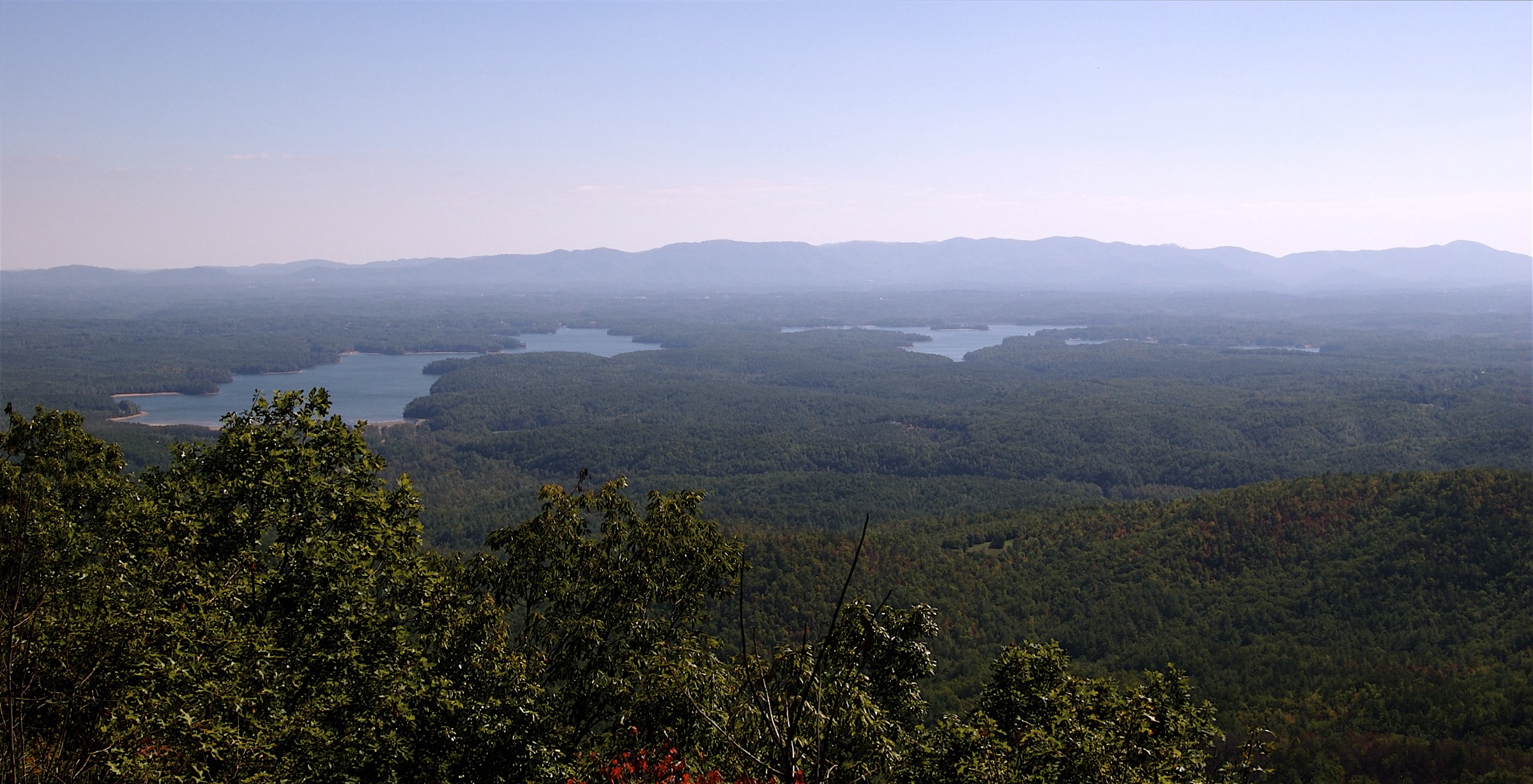
Two view products sit on this water, and they are not the same day. Shortoff Mountain is the climb from the dead end of Wolf Pit Road, a gravel spur north of the lake off N.C. 126, to open rock with Lake James south and Linville Gorge north. The common day hike is on the order of 4.5 miles round-trip. Summit elevation is commonly listed near 2,883 feet. Confirm mileage, gain, and any U.S. Forest Service or Linville Gorge Wilderness alerts the week you go. This is a climb, not a paved overlook.
Lake James State Park is the other product. Paved and graded park views from Paddy’s Creek and the shorter Catawba River trails are the stroller, sunset, and we still have to make the Charlotte drive Sunday views. The official park trail table names Lake Channel Overlook Trail at 1.5 miles one way and Sandy Cliff Overlook Trail at 0.5 mile one way. Holly Discovery and Homestead are the easy family walks. Chimney Rock State Park is a different lake basin and a locked cluster. Do not send them.
This is not thecomplete visitor’s guide. It is not theFonta Florabike-and-walk day. It is not a second Linville Gorge encyclopedia. Parking, season, restrooms, and whether you can see this lake without a 1,300-foot climb are the job. Hero is Shortoff looking down at Lake James, or a park overlook looking across it. Keep the two products on two clocks. A climb and a park ridge are not one caption, and they are not one Saturday.
Two view products, not one caption
Write the day you can keep. A Shortoff morning starts on gravel, carries water, and accepts a front-loaded climb. A park morning starts at a signed lot, uses a restroom, and can still reverse toward Charlotte before the inbound thickens. Hosts who mash those two products into one listing sentence are already writing the review about a hike the guest did not pack for. Visitors who book a 3-bed dock house and then invent a gorge passport before lunch are writing the same tired review about their own itinerary. Pick one product. Pack for that product.
Theweekend from Charlottecan hold one of these products on Sunday, not both. The complete guide can hold Shortoff as day three. This page keeps the split honest. Shortoff is wilderness-area trail. The park is a state-park clock with a visitor center at Paddy’s Creek, a seasonal swim beach, and day-use hours that shift from about 7 a.m. to 7 p.m. in midwinter to about 7 a.m. to 10 p.m. in summer. Closed Christmas Day. Confirm the live park page.
Do not caption a park ridge as Shortoff because the listing needed a gorge noun. Do not caption Shortoff as a stroller walk because the house sleeps small children. Do not caption either view as Chimney Rock, Rumbling Bald, or Lake Lure. Those belong to a different basin and a locked cluster. One honest pin at breakfast beats three borrowed overlooks by lunch. The photograph should look at this lake. If the frame could be any ridge in western North Carolina, it is the wrong frame. Write the product the guest can finish before dinner in Marion or Morganton NC.
Wolf Pit Road is the trailhead, not a paved lot
The trailhead is the dead end of Wolf Pit Road, gravel, north of the lake off N.C. 126. Common approach language sends you along N.C. 126 to Wolf Pit on the left, then about 2.5 unpaved miles to a turnaround. Parking is limited and unsigned in the wilderness-area style. There is one trail at the end of the road. After a few minutes some hikers note a homemade sign to turn right for Shortoff. Recheck that the week you go. Roads move. Signs vanish. A mapping pin is not a paved lot with a kiosk.
Wolf Pit Road conditions are part of the page. Gravel, washboard, and weather after a storm are the real gate, not a paved state-park lot. A low sedan on a wet Saturday is a different decision from a higher-clearance car on a dry October morning. This draft will not invent a road rating. Look at the surface the week you drive. Do not block the turnaround. Do not treat the dead end as overflow parking for a party dock. There are no restrooms and no water at the trailhead.
Do not send a Fonta Flora guest up this spur because the names sit near each other on a map. Wolf Pit as a Fonta Flora access pin is a different product on the Burke trail page. The gorge climb from the dead end is this page. Confirm U.S. Forest Service and Linville Gorge Wilderness alerts before you promise the rock. If the road is a mess, the park overlooks still exist. That is the honest substitution, not Chimney Rock. A closed gravel spur is not a reason to steal another lake’s overlook.
The common day hike is about 4.5 miles to the open rock
The common day hike is on the order of 4.5 miles round-trip to the open rock, with Lake James south and Linville Gorge north. Summit elevation is commonly listed near 2,883 feet. Secondary writeups often print about 1,200 to 1,321 feet of gain, with the first mile as the steep, rocky, switchback climb and the last stretch as a broader summit walk. Confirm mileage and gain on U.S. Forest Service notes the week you go. AllTrails-class numbers are a check, not a source of truth. This draft will not invent a difficulty badge or a guaranteed hour.
This is a climb, not a paved overlook. Boots, water, sun, and a winter ice note if you draft in shoulder. The first mile can be hot and thinly shaded after the old fires. Start early in summer. Long pants help where the wilderness trail is not trimmed like a state-park path. Dogs, where allowed, belong on a leash. This page will not invent a difficulty badge. If the group is not fit, open the park half of this page and leave Wolf Pit for another trip.
At the rock you should see this lake. That is the hero. Linville Gorge opens the other way. Do not collect Table Rock, Hawksbill, Wiseman’s View, and Linville Falls into the same Saturday. Those are other gorge days. This page is Shortoff looking down at Lake James. Turn around. Retrace. Get off the gravel before dark. Camping in the wilderness has its own permit season through the Grandfather Ranger District. Confirm if you are staying out. Most dock-house guests are not. They came for the water and one view, not a backpacking permit.
Confirm USFS and Linville Gorge alerts the week you go
Wilderness alerts move. Storms move trees. Ice moves the first mile. Confirm U.S. Forest Service and Linville Gorge Wilderness notices the week you hike, not the week the listing was written. Helene-era damage still belongs on the verify list for any N.C. 126 approach. The Burke Fonta Flora page still advises a bypass on the Wolf Pit-to-Linville River trail section along N.C. 126 until repaired. That is a trail-day hedge for theFonta Florasibling. It is also a reminder that the highway shoulder is not a guaranteed sidewalk to the climb. Confirm the road and the trail as two different questions.
Do not invent a closure this draft cannot screenshot. Do not invent an open stamp either. Print the live alert. If Wolf Pit Road is a mess, say so in the house manual that weekend. Hosts who sell Shortoff as a casual add-on from a Friday 5 p.m. Charlotte arrival are already arguing with daylight. Theweekendpage wants an early Sunday start if Shortoff is the one hike, then the reverse on I-40 East and I-77 South.
Winter is possible on this south-facing rock and is often sold as a sunny hike. Ice on the first mile is still ice. Shoulder guests who wanted a park overlook should not be sent up Wolf Pit because October is a peak lodging month. Peak-three on the AirROI file is August, June, and October. October is a gorge-and-leaf Saturday for the fit guest. It is a park-overlook Sunday for everyone else. Write the product the house can host. Confirm the alert. Then walk. A listing that sells both as casual add-ons is already arguing with daylight.
Park overlooks are the stroller and Sunday-drive views
Paddy’s Creek Access sits at 2229 Lake James State Park Road, Nebo. Visitor center, swim-beach ridge, and Fonta Flora bridges are the signed park views. Catawba River Access at 2785 N.C. 126 holds about 4.5 miles of quieter trail. The official park trail table names two overlook walks without poetry: Lake Channel Overlook Trail, 1.5 miles one way, moderate, red diamonds, hiking only. Sandy Cliff Overlook Trail, 0.5 mile one way, moderate, white circles, hiking only. Those are the names. Do not invent new ones.
These are the views you can finish when Sunday still has to reverse toward Charlotte. Day-use is free except swim passes and rentals. Confirm fees on the park page the week you go. Restrooms and water live at the visitor center, not on every spur. Swim beach runs 10 a.m. to 6 p.m. from 1 May through 30 September. Pets are leashed, off the beach, and out of buildings. Hidden Cove boat ramp closes January, February, and December. Canal Bridge stays 24-hour. None of that is a gorge climb. It is the park clock. Use it.
Do not rebuild the Fonta Flora ride here. Do not rebuild the three-day guide. One park overlook is the product. Two overlook encyclopedias plus Shortoff plus a boat reservation is the scavenger hunt that misses dinner in Marion or Morganton NC. Hosts should photograph a park ridge only from a door that can actually reach the lot on the clock the listing wrote. Visitors should refuse a caption that sells Chimney Rock views from this overlook. This basin is enough if you let it be one view.
Holly Discovery and Homestead are the family walks
Holly Discovery, also printed as the K.I.P. Track Trail, is a 0.75-mile loop, easy, red triangles, hiking only on the official table. Homestead Trail is 0.7 mile one way, easy, blue and white triangles, hiking only. Destination McDowell and park materials treat both as the family default. They are not Shortoff. They are not a 1,300-foot climb. They are the walks you can do after a lake morning and still keep a dinner hour.
Paddy’s Creek Trail is 1 mile one way, moderate. Overmountain Victory through the park is about 2 miles one way, easy, hiking only. Fishing Pier Trail is 0.3 mile one way at Catawba River. Fox Den Loop is a 2.25-mile loop on that quieter side. Name those only when the guest asked for a longer park walk. Do not stack them on top of Shortoff. Do not stack them on top of a Fonta Flora bike day. One family loop is enough for a dock-house Saturday that already used the water.
East Wimba is not a family walk this season. The park page has East Wimba on long-term closure after Helene. A footbridge is also closed for repairs on the southern leg of Overmountain Victory. Verify both on the live alerts the week you go, then do not send people to a closed loop. Holly Discovery and Homestead remain the honest short walks when you still have to see the lake and get back to the pin before dark. That is the family product. Keep it short enough to keep dinner.
East Wimba is closed. Do not send people there
The park’s own status line is blunt. Hiking trails are mostly open. Biking trails are mostly open. The East Wimba Trail is on long-term closure due to damage from Hurricane Helene. A footbridge is closed for repairs on the southern leg of the Overmountain Victory Trail. Verify, then write the house manual without that loop. A listing that still sells East Wimba as a Saturday bike is already arguing with the park.
Helene is a verify-at-draft note, not a scare lede and not a Lake Lure recovery story. Stay on this park’s alerts. If a different spur closes the week you host, print that alert instead. Do not invent a reopening date this draft cannot screenshot. Do not send the guest to Chimney Rock as a consolation overlook. Different basin. Locked cluster. The park still has Lake Channel Overlook, Sandy Cliff Overlook, the swim-beach ridge in season, and the Fonta Flora bridges with this lake in the frame.
Hosts should replace miles of hiking with a named walk that is actually open. Visitors should treat a closed trail as closed even when a three-year-old blog still maps it. TheFonta Florapage is the bike-and-walk substitute that stays on the water. Shortoff is the hard hike when the alerts are clean and the group is fit. East Wimba is neither until the park says otherwise. Print the alert in the house manual that weekend.
What to photograph, and what not to steal
Photograph Shortoff only when the frame looks down at Lake James, not at a generic gorge postcard that could be anywhere. Photograph a park overlook only when the water in the frame is this lake. Do not borrow a Chimney Rock sunset. Do not borrow Lake Lure Beach. Do not borrow a Lake Norman peninsula skyline. The Peninsula at Lake James is a different community on this water and is not a viewpoint name. Keep the nouns apart.
Hosts writing listing copy should pick one view product for the first six frames. A collage of Wolf Pit gravel, a stroller loop, and a movie-lake overlook is how you earn the review about a hike the guest never wanted. Thehow to marketpage already said 75 to 90 minutes from Charlotte, not Dirty Dancing. This page supplies the named rock and the named park overlooks. Use them. Do not invent poetic trail names the official table does not print.
Visitors should keep the same discipline. One climb or one park overlook. Confirm Wolf Pit Road, confirm the park hours, confirm the closures. Return to the dock you are paying for before dark. Grocery and dinner stay in Marion NC or Morganton NC. Morganton NC is not Morganton GA. Asheville is not the origin and not the add-on. The complete guide is the longer menu. The weekend page is the timed loop. This page is the view that actually looks at Lake James. Keep Chimney Rock out of the caption.
Related Reading
More Nebo, Lake James, McDowell, and Burke shoreline reading already live on Crest & Cove.
The 3-Bed Dock House on Lake James — Not the 7-Bed Party Dock
McDowell vs Burke: The Parcel Test Before You Buy on Lake James
How to Market a Lake James House: 75–90 Minutes From Charlotte, Not Dirty Dancing
Greybeard's 8 and Evolve's 6: Is an Agency Worth It on Lake James?
Is a Lake James Dock House a Good Short-Term Rental Investment in 2026?
Lake James Shoulder Season: April, May, and September — Not a Generic Winter Template
A Remote Week on a Lake James House Built for 4-Night Summers
Who Books a Lake James House: Lake Weekend, Gorge Day, and the Party You Should Refuse
McDowell County Tourism Data: What Visitors Spend, Not What Hosts Earn
What It Actually Costs to Start a Lake James Airbnb — Dock and HOA First
Financing a Lake James Dock House: DSCR vs Second-Home on a $2,847 Median
A Fonta Flora Trail Day From Nebo: Bike and Walk, Not Shortoff
Frequently Asked Questions
How long is the common Shortoff hike from Wolf Pit?
On the order of 4.5 miles round-trip to the open rock. Summit elevation is commonly listed near 2,883 feet. Secondary writeups often print about 1,200 to 1,321 feet of gain. Confirm mileage, gain, and U.S. Forest Service or Linville Gorge alerts the week you go. This is a climb, not a paved overlook. The common day hike is on the order of 4.5 miles round-trip to the open rock, with Lake James south and Linville Gorge north.
Where is the Shortoff trailhead?
The dead end of Wolf Pit Road, gravel, north of Lake James off N.C. Common notes print about 2.5 unpaved miles to a limited, unsigned turnaround. No restrooms and no water at the trailhead. Road conditions are part of the day. Do not send a Fonta Flora guest up this spur by accident. Shortoff Mountain is the climb from the dead end of Wolf Pit Road, a gravel spur north of the lake off N.C.
Is Shortoff the same as Chimney Rock?
Chimney Rock State Park is a different lake basin and a locked cluster. Do not send Lake James guests there as a nearby overlook. Do not borrow that sunset for a Nebo listing. Shortoff looks down at this lake and into Linville Gorge. Keep the nouns apart in the listing and on the trail. Photograph Shortoff only when the frame looks down at Lake James, not at a generic gorge postcard that could be anywhere.
Which park overlooks can I name?
Lake Channel Overlook Trail is 1.5 miles one way, moderate. Sandy Cliff Overlook Trail is 0.5 mile one way, moderate. Holly Discovery is a 0.75-mile easy loop. Homestead is 0.7 mile one way, easy. Confirm the live park map the week you go. The official park trail table names Lake Channel Overlook Trail at 1.5 miles one way and Sandy Cliff Overlook Trail at 0.5 mile one way.
Is East Wimba open?
The park page has East Wimba on long-term closure after Hurricane Helene. A footbridge is also closed for repairs on the southern leg of Overmountain Victory. Verify the live alerts, then do not send people to a closed loop. Holly Discovery and Homestead remain the honest short walks this season. The park page has East Wimba on long-term closure after Helene.
Can I see the lake without the 1,300-foot climb?
Paddy’s Creek visitor center, the swim-beach ridge in season, Fonta Flora bridges, Lake Channel Overlook, and Sandy Cliff Overlook are the park product. Day-use is free except swim passes and rentals. That is the Sunday-drive view, not Wolf Pit. The park still has Lake Channel Overlook, Sandy Cliff Overlook, the swim-beach ridge in season, and the Fonta Flora bridges with this lake in the frame.
Should a first-time weekend try Shortoff and a park overlook?
The Charlotte weekend page can hold a short park view or Shortoff if the group is fit and starts early, then reverse I-40 and I-77. Stacking both plus a boat reservation is how you miss dinner in Marion or Morganton NC. One view is the Sunday product. Two overlook encyclopedias plus Shortoff plus a boat reservation is the scavenger hunt that misses dinner in Marion or Morganton NC.
Does this page rebuild Fonta Flora or the three-day guide?
Fonta Flora is the lake-level bike-and-walk sibling. The complete visitor’s guide is the three-day hub. This page is Shortoff from Wolf Pit and the named park overlooks that look at Lake James. Confirm alerts the week you go. Do not steal Chimney Rock for the caption. This page supplies the named rock and the named park overlooks.
Should I confirm uSFS and Linville Gorge alerts the week you go?
126, to open rock with Lake James south and Linville Gorge north. The common day hike is on the order of 4.5 miles round-trip to the open rock, with Lake James south and Linville Gorge north. The common day hike is on the order of 4.5 miles round-trip. Hosts should replace miles of hiking with a named walk that is actually open.
What to photograph, and what not to steal?
The photograph should look at this lake. Photograph a park overlook only when the water in the frame is this lake. Photograph Shortoff only when the frame looks down at Lake James, not at a generic gorge postcard that could be anywhere. Hero is Shortoff looking down at Lake James, or a park overlook looking across it.
Work with Crest & Cove Creative
Need the Shortoff and park-overlook page that actually looks at Lake James?
Reach out at crestcove.co or (256) 998-7502.


Comments